As Tropical Storm Michael continues to move through the Carolinas and back into the Atlantic Ocean, it may have significant after-effects on the Jacksonville area.
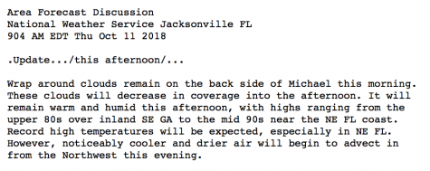
According to the forecast by the National Weather Service, the area will remain warm and humid through this afternoon, with temperatures staying in the mid 90s near the northeast Florida coast.
The forecast also says that “record high temperatures will be expected” in northeast Florida.
However, a cold front carrying cooler and drier air is coming in from the Northwest, and is expected to arrive sometime this evening.
Michael left a path of destruction across the Florida panhandle and surrounding areas after it made landfall as a Category 4 storm on Wednesday. According to various local electrical providers, more than 800,000 homes have lost power in Alabama, Florida, Georgia and South Carolina as a result of the storm.
Michael is expected to leave the mainland United States by Friday morning. From there, it is projected to remain a tropical storm as it continues eastward across the Atlantic Ocean.
—
For more information or news tips, or if you see an error in this story or have any compliments or concerns, contact [email protected].