Part of the University of North Florida’s (UNF) 50th anniversary, two university speakers gave a presentation as part of the UNF library’s Speaker Series, where they unveiled a new in-depth digital map showing the evolution of the UNF campus over 50 years.
Using various methods, professor Chris Baynard and Assistant Director of Research Technology Services Robert Richardson obtained birds-eye pictures of the entire UNF campus this year, all compiled and stitched together to create a massive in-depth visual aid of UNF’s current layout.
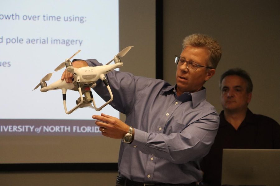
They started their presentation explaining the four methods used to take the pictures: drone, kite, balloon, and pole:
Drone
Utilizing drones to take these pictures, while in theory sounding like the easiest method to do so, it’s actually the hardest. There are many restrictions regarding drone flight. Untethered drones cannot fly above 400ft in the air, and the pilot must be registered with the Federal Aviation Administration (FAA). Various other hoops must be jumped through, and permissions secured for drone flight. They explained how even despite all that, their current drone soon won’t be allowed to fly at all, given security concerns as a result of its production in China. All these factors make drone photography the least optimal method.
Kite:
Kite Aerial Photography (KAP) is achieved by attaching a camera to a kite. Baynard showed off a giant kite, which could be attached to an auto-balancing device that ensures the lightweight camera always faces the right way. The weight of the camera was obviously a concern for all of these photography methods.
“Will it hold everything you need?” Baynard explained the thought process behind it.
Tethered flights from balloons and kites are also much less regulated, so they can fly as far as the line connecting them to the ground, which in their case, is 500ft. An obvious drawback to KAP however is its reliance on the wind.
Balloon:
Balloon Aerial Photography (BAP) is similar to KAP, in that it is also tethered and can reach 500ft as a result. Baynard showed off the large balloons they filled with Helium and attached a camera to. BAP doesn’t need wind like KAP, but its reliance on Helium is another hurdle to overcome. Helium, while not regulated, is still expensive. Thankfully, they are provided Helium courtesy of the Environmental Center. However, this can only be done inside of the building, so they must fill large balloons several feet in diameter through tight doorways, so they are prone to popping.
Pole:
Pole Aerial Photography (PAP) is the simplest method of aerial photography. It involves just attaching a camera to a painter’s
pole and that’s it. It’s simple, yet obviously doesn’t go very high, but can still lead to interesting aerial shots regardless. For PAP, KAP and BAP, they also use custom designed holders that they 3D print to help attach and stabilize the cameras themselves.
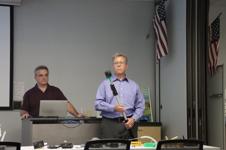
Speaking of the cameras, Baynard showed off many different ones that they use, but admitted “It’s hard to beat the GoPro” for its lightweight, small size, and durability.
Through these methods, they would go back and forth across the campus one row at a time in a similar vein to mowing a lawn, all in order to get clear aerial shots of the entire campus. These were then stitched together using precise measurements to make sure it’s completely accurate
But why would they spend all this time doing this? Photography methods were only half of the whole presentation.
The second part of their entire project involved getting aerial photos from as far back in time as they could. The earliest they were able to find was from 1959.
“We ended up finding 27 years of aerial photos,” Richardson remarked.
These photos were taken from many different places, including the Library’s Digital Commons, and the Florida Department of Transportation. These photos, while not from every year, were enough for the professors to create a digital map website that allows easy access to a properly scaled map and easy comparison to the modern-day map.
This digital map allows a greater understanding of how UNF’s landscape has changed over 50 years, starting from 1000 acres to its current size of 1380 acres. It also includes a tab to show land usage between different entities every year.
They also explained how online map resources often aren’t up-to-date, and don’t include past information data.
“Just because it’s on Google Earth doesn’t mean it’s accurate” Baynard stated.
The fruit of their work is an incredible project that shows a fantastic evolution of UNF over 50 years, and the impressiveness of it cannot be understated, and the website isn’t even finished yet!
The professors were adamant that the website still isn’t finished yet, but its current state is still remarkable.
As for the future, besides updating their site with more options, they plan on also adding a Virtual Reality element to their project with 360-degree imagery and walk-through models, in conjunction with the UNF VR Lab in the Library.
This was accomplished through 360 pictures taken by Richardson in 2020 whilst the campus was empty due to COVID-19.
“You can go back in time, you can see how things looked,” said Baynard, summing up their work.
A digital recording of the panel taken via Zoom can be found here.
Their website can be found here and is definitely worth checking out.
___
For more information or news tips, or if you see an error in this story or have any compliments or concerns, contact [email protected].